


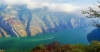
Ala Archa Natural Park is located approximately 40 km south of the capital city of Bishkek in the region's largest gorge also named Ala-Archa. It is here, in the narrow valley of an ordinary small river that you may see a concentration of wonderful landscapes, stunning waterfalls, and amazing rock formations. The alpine park covers an area of 200 km² (20,000 hectares) and stretches for over 35 km (22 miles) of the western Tien Shan (Celestial Mountain) range. The national park’s altitude ranges from about 1,500 meters (5,000 feet) at the entrance to a maximum of 4,895 meters (16,000 feet) at Semenova Tian-Shanski, the highest peak in the Kyrgyz Ala-Too range. Located on the north slope of the central part of the Kyrgyz Tien Shan ridge, the park has become in many ways the symbol of Ala-Too itself.
The region's most famous and highest peaks of the Ala-Too Mountains rise out from the Ak-Sai glacier, including Korona (4860m), Semenov-Tyan-Shan peak (4875 m) and Free Korea (4740m). All higher than anything Europe has to offer, alpinists from all over the world gather here to conquer the summits of these peaks. In addition to more than 50 total mountain peaks, the Ala Archa gorge also is home to more than 20 small and large glaciers and 30 mountain passes. Trekking to almost 5000m is possible, although most people stay near the lower reaches that are often used for picnics. 140 classified mountaineering routes of various levels of difficulty/complexity have been mapped out, but there are still more to be topographically explored. Every May 1st, the Alpinada festival sees hundreds of people camp out in the valley and climb Mount Komsomolets.
While the park’s principal river is, of course, its namesake, the Ala-Archa, there are two smaller rivers, the Adygene and Ak-Sai, that are also fed by glacial melt-water. The Ala-Archa River originates from the glaciers of northern slopes of the Kyrgyz Ala-Too, tumbles down through the reserve, skirts alongside fir forests, and flows past green meadows where it finally joins the Chu River. It has several tributaries: the Ak-Sai, Top Karachi, Teke-Terre, Tuy-Suu Adygine, Jindi-Suu. The Ala-Archa River flows north, is 78 kilometers (48 mi) in total length and has a basin area of 233 square kilometers (90 sq mi).
The park, which includes the gorge of the Ala-Archa River and the mountains surrounding it, used to be a former Soviet campsite for climbers in military training. Ala Archa development began as solely tent camping in 1951, but as it's popularity grew, so did its size. For alpinists it became one of the most popular places in the world for climbing; only the Caucuses drew larger numbers of Soviet mountaineers. By the latter half of the 20th century, Ala-Archa has firmly established the alpine Mecca of Central Asia and many-storied climbers started their alpine career here. The park is open year-round, although the most popular season is late summer and early fall.